Carl Wolff's Historischer Atlas : neunzehn Karten zur mittleren und neueren Geschichte 1877
Maps covering the history of boundary changes in central Europe. The western border of Poland and the Polish-Lithuanian
Commonwealth are well documented as is the growth of the Austrian Empire.
Source: Polish National Library
|
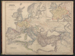
Europa um das Jahr 500
|
 |
|
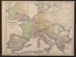
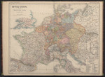
Sud-Und Westeuropa nach der Theilung des frankischen Kaiserreiches zu Virodunum im Jahre 843
|
 |
|
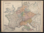
Mittel-Europa im Jahr 1000
|
 |
|
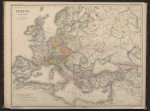
Europa im Jahre 1150
|
 |
|
Mittel-Europa im Jahre 1250
|
 |
|
Deutschland biem Tode Kaiser Karls IV im Jahre 1378
|
 |
|
Mittel-Europa nach seiner kirchlichen Eintheilung um die Mitte des XV. Jahrhunderts
|
 |
|
Sud-Und Westeuropa biem Tode Karls des Kuhnen im Jahre 1477
|
 |
|
Deutschland bei der Thronentsagung Kaiser Karls V. im Jahre 1556 (a)
|
 |
|
Deutschland bei der Thronentsagung Kaiser Karls V. im Jahre 1556 (b)
|
 |
|
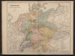
Mittel-Europa nach dem Westfalischen Frieden im Jahre 1648
|
 |
|
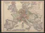
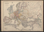
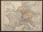
Europa im Jahr 1721
|
 |
|
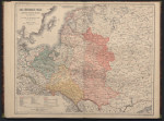
Das Konigreich Polen nebst dem westlichen Russland im Jahre 1772
|
 |
|
Deutschland biem Ausbruch der Franzosischen Revolution im Jahre 1789
|
 |
|
Deutschland nach der Auflosung des Deutschen Reiches im Jahre 1806
|
 |
|
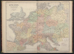
Mittel-Europa zur Zeit der hochsten Machtentfaltung Frankreichs im Jahre 1812
|
 |
|
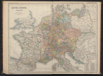
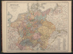
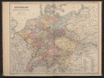
Deutchland zur Zeit des deutchen Bundes 1815-1866
|
 |
|
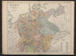
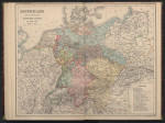
Mittel-Europa nach der Wiederaufrichtung des Deutschen Kaiserreiches im Jahre 1871
|
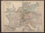 |
